
Scrappy Tandale
Posted: February 1st, 2013 | Author: mikel | Filed under: tandale, Tanzania | Leave a comment »Last week, Gary Gale and I chatted about Tandale, Dar es Salaam. I reached out to Gary after he posted about his visit, (also see the Tandale group’s blog post about it). I saw that he was really affected by the challenge of life there, but also inspired by the small hopes that mapping has opened up, and the voracious enthusiasm of the Dar tech community. I feel the same; a deep responsibility, especially to the individuals in this community that are truly dedicated to change, and have taken the chance to believe in the vision of openness. Despite it being 1.5 years after the initial Tandale pilot, with no sure follow up in sight, we haven’t let go. We support Msilikale Msilanga, former Ardhi student, and he in turn supports the community members to keep up with reporting. We have left sets of equipment on loan there.
I recounted my perspective on the whole odyssey, complementing what he’d heard from Mark. Basically, Tandale started as a successful pilot, with lots of promise and excitement from the community, the students, the local government, and the World Bank. And that excitement continues to this day — Tandale is often highlighted as a symbol of the potential of community mapping. But for whatever systemic and accidental reasons, the elements haven’t come together to fully continue the project in the way it deserves, to deepen and expand across Dar. There’ve been a lot of meetings, several different plans. It’s frustrating, but understandable. GroundTruth took it on ourselves to draw up the project details to build up the tech and program, especially connecting the voices of the community to mainstream media, and sought support from the Africa News Innovation Challenge. We got very close, all the way to the finals, but not to the finish line; perhaps we didn’t hit all the right phrases on the bingo cards. We still believe the concept is very sound and substantial, rooted in real experience and need, and we are still looking to make it happen. Let’s talk if you have ideas.
In the mean time, we all do whatever we can. We’re scrappy. All of the original equipment was destroyed in flooding in late 2011, tragic, but typical of the risk of the high water table and unplanned development of Dar es Salaam. Last June, we were able to bring a little more equipment to Tandale. And due to the ongoing, amazing, inspiring dedication of folks like Msilikale and the residents of Tandale, we managed to help start an ongoing blogging group there, as well as to support CCI’s expansion of mapping to another settlement, Keko Machungwa.
They results are absolutely impressive. The Tandale Blog fully covers the events and issues of Tandale. It is sustained purely with the motivation of community members and their interest in making known the challenges they face in the hopes that they can be more visible and guide government resources to the area. This keeps me going.
Talking with Gary, he in interested to help out, however he can, as a remote mapping geek. I thought I’d just share publicly the top simple tech tasks. Basically we have the Tandale blog, and an empty and waiting Keko blog. Both of these could use some design attention, and perhaps integration of translation. They’re both missing maps; though almost every post is associated with a place in the community. There are lots of ways that could happen. We’ve set up Ushahidi for Tandale before, but there are technical issues with using it in low bandwidth environments (a strange “Error -1”), and I’m not sure how well coupled it is with the blog. And perhaps, Ushahidi should be set up to cover all of Dar, incorporating numerous feeds, to provide a mapped overview of all the conversations happening Dar-wide.
This could be a great chance for young techies to gain experience in a real practical project. There are enthusiastic young people gathering in places like TanzICT and KINU. Gary could start building mentor relationships with these folks, and that could go far. Mobile phones and ICT of all kinds are mushrooming in Dar, and home-grown spatial applications, especially building on high quality OpenStreetMap data, could open new markets. On the other hand, mentoring takes twice as much time as just doing it yourself, so we’ll need to figure out what will really work for Tandale.
If any of this strikes a chord with you, or you have any scrappy or long term ideas for supporting motivated, grassroots communities, please get in touch.
Chalakudy and River Basin Open Data
Posted: November 24th, 2012 | Author: mikel | Filed under: India | Leave a comment »I’m trying to gather thoughts from our whirlwind spin mapping and documenting through the Chalakudy River Basin with The Blue Yonder friends; and connecting to various other half formed ideas and unprocessed experiences. You might experience a little whiplash through the mental landscape, but no worse than than the twists and turns of Kerala roads…

The last remaining sand bank on Chalakudy River. It remains due to local agitation and proximity to religious sites. The rest have disappeared to sand mining
We have decamped 12 kms from Chalakudy, The Blue Yonder is renting us a hotel room (in five hour increments) to take advantage of the sort-of usable wifi, and crush the last few days of experience and ideas into software, maps and media. Passing by in the streets below is a jeep, flying the hammer and sickle flag, announcing monotonously and over loud-speaker in Malayalam, appointments to various local committees. Prakash is uploading videos and making reports on an Ushahidi instance running locally on my laptop, configured with custom map tiles resulting from another three days of epic drives of Kerala (that platform is now online here. Every responsible tourism spot we’ve visited is being sketched in a report, pictures, videos; and already mapped in OpenStreetMap (tourism=responsible). I’m excited for how many ways openness can share and preserve the amazing culture and environment of the Chalakudy river basin in Kerala. Like everywhere, Kerala faces extraordinary global pressures, and I notice how collective and individual efforts are in an everlasting interplay to protect, undermine, inspire, catalyze, smother, build and destroy these experiences and environments, yet again reflected in the global rush to digitize and connect to the global brain.

fishing by stick is a reality
Chalakudy is Kerala’s most wild river, with the highest biodiversity of all Keralan rivers, largely lying within the rugged landscape of a forest reserve. Each morning, with several cups of chai acquired from the road side shop down the way (poured in meter long hand movements by a woman who works every sunlit hour, and many dark ones, except for a half day break on Sunday) (the road is the former tram way built by the British to expedite extraction of virgin teak forests, used among other things for reinforcing N African trenches in WW1), I read through Dr. Sunny George’s epic integrated atlas-like report on the Chalakudy watershed, covering everything from the settlement history and demographics of “scheduled tribes” (as designated in India, indigenous people who have retained their identity and largely way of life through thousands of years of contacts with various ruling structures), to land use changes over the past decades (conversion of rice patties to clay mining or conventional framing, planting of oil palm along river banks, historic exploitation of massive teak forests, and the numerous effects on water flow, retention and livelihood), to pages of tabular data indicating worrying declining flow of the river overall, to the wide diversity of traditional inland river fishing styles (reflecting fish biodiversity, and even including the unbelievable technique of catching fish between two slowly closing sticks). It’s a wonderful primer to understanding this place, and its locked away in 400 loosely bound pages; the floppy disks holding the soft copy have perished to mold sometime in the past 10 years. Its information and data that’s difficult, almost impossible, to share and utilize, yet should be required reading for anyone making decisions about the watershed. Yet it represents only the slightest beginning of the knowledge actively enmeshed in the landscapes and cultures of Chalakudy.
Open Data Watershed

A watershed is a natural ecological and cultural boundary, plainly obvious when you know to look for it. So much of the environment and character of a place, its inter-dependencies and issues, are based not on the numerous and complicated overlap of administrative boundaries (as evidenced by the long list of offices and sources consulted for compiling in the Chalakudy report), but rather the way water flow shapes landscape and human settlement. Cities are a natural organizing principle (though only I learned at Meeting of the Minds a formal focus of study more recently), and have easily grown into the framework of Open Data (also coinciding w/ #motm12, was launched the aggregate city site cities.data.gov). Like cities, open Watersheds can be a movement with real legs, to share environmental data and build on the models of engagement across disciplines evidenced in other Open Data movements. And of course, cities are intertwined with watersheds, traditionally founded on strategic points on rivers. Conceptually, it can easily attract coders, policy makers, scientists, historians, students who have already grasped Open Data; while the watershed is a geographical unit of focus that is tangible and practical. Watersheds are nested, fractal-like structure, so that data can be shared and compared across watersheds of similar scale (through the evolution/conversations of tagging structures/flexible taxonomies) (similarly, in Cairo, Takween and Diane Singerman were developing taxonomies to more easily understand, compare, develop interventions, and support grassroots learning in informal settlements). And watershed data can be generalized to contribute to larger scale models and policy, ultimately to the global level.

The Blue Yonder is developing the idea of design workshops, where experienced and student designers hold a month or two residency with a traditional crafts group in Chalakudy (like the Bamboo Craft workshop) and develop ideas which could be marketable to tourists and abroad (products from the Natural Fibre Craft Resource Center even now is marketed by IKEA). The same could be done for data. A big start would be looking at updating and translating to the web the Integrated Study of Chalakudy. And OpenStreetMap is an ideal platform to model and implement part of an integrative approach. In OSM, land use, water structures, tourist infrastructure are all stored together in a single database, yet seperatable for particular visualization and analysis.
Next couple posts will dig into more how open data and community media complement a responsible tourism approach, leading we hope to a methodology for addressing the issues facing river basins, as well as some more technical ideas and directions.
Ard El Lewa field workshop
Posted: September 24th, 2012 | Author: mikel | Filed under: Cairo | 1 Comment »
As mentioned in a previous post, we’ve been here in Cairo for the past couple of weeks working with local architects, techies, grassroots activists, and interested residents of the Ard el Lewa community on a quick demo and experiment intended to catalyze the use of open technologies at neighborhood level.
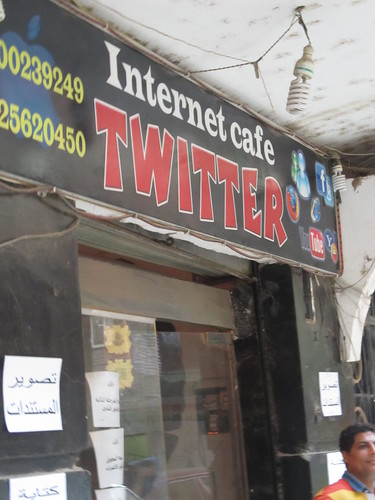
Four four evenings, after the work day was done, we gathered in the screening room of Art El Lewa, an artist space, or next door in the “Twitter” cyber, made this small but good start on mapping Ard El Lewa, and posted a few reports to this demo neighborhood CrowdMap. At the end, on my birthday, I received a great present with the announcement of formation of an Ard El Lewa OSM group!
Here’s the before and after. Look closely. From absolutely no POI features at all, there’s over a dozen mosques, churches, schools, bakeries, parking; and several corrections to street names and additional streets. This was edited in just a couple of hours.
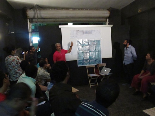
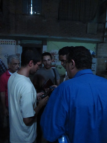
There was a terrific amount to cover in a few quick evenings, not only the techniques of OpenStreetMap and Ushahidi, but more fundamentally, the concepts of thinking and working geographically toward a particular outcome. Zaazaa from Megawra and Omar from Cluster led the initial meeting, in a packed room of participants, including about 12 from Ard El Lewa: from the youth center, popular coalition, political parties, women’s groups; and another 12 from groups outside with interest in the process. Ard El Lewa has strong grassroots networks, and Cluster has been collaborating with them, so it was easy for them to mobilize. Everyone drew conceptual maps on paper of their journey from the bridge (over the railway, one of the few entrances to Ard El Lewa), to Art El Lewa, and we explored the different ways of representing and thinking about space. Then a “find my house” session with Google Earth, that could’ve gone on for hours.
Most interesting were presentations from a few local amateur mapmakers, including a grassroots leader and tailor whose hand-drawn detailed designs for a new transit station at the entrance to Ard El Lewa clearly reflect the attention to detail in his day job craft. And another presentation by a young researcher, who’s been collecting street names and their history in Ard El Lewa, using spreadsheets and hand drawn maps; the names are usually sourced from the first person to build on the street, the name of the canal that formerly laid there, a nearby shrine, or some other prominent landmark. And if that wasn’t enough, Abdelrahman comprehensively covered the basic concepts of OpenStreetMap and GIS, including the differences between raster and vector data.
The second day got everyone into the streets, with GPS, and they totally got it, and collected an epic number of points. Ahmad from ADEF learned the GPS in the car ride over, and delivered the training on arrival. Afterwards a detailed demonstration and training on JOSM was conducted in the cyber.
On the third day, we presented some examples of how we’ve used maps and media elsewhere, and then Omar led a discussion session to brainstorm uses of the maps and reporting tools locally. This was one of the most inspiring moments, ideas growing from expected things, like using the maps in the planning of new infrastructure in Ard El Lewa, to things like custom book covers for local school children illustrating the location of their school on the map, mapping graffiti art works, developing a website for the community including job postings, and a local business oriented map, whose collection and distribution could create entrepreneurial opportunities for local youth (this idea from the local youth themselves). There were many more that flew by me in Arabic, but honestly, I’ve never seen a community so ready to put technology to work for their own agenda.
It’s true, the number of attendees reduced over the week, which is pretty typical. But the remaining core represented most of the folks from Ard El Lewa, now a seemingly dedicated lot. The rest of the two days focused on using registering with OSM, using JOSM, and using Ushahidi. We discussed how to tag the narrow, unpaved roads of Ard El Lewa, something which seems to require new classifications. The Ard el Lewa Ushahidi crowdmap instance took some of the concepts from the previous days, and put them together onto a website. Those who had stuck with the training until the fourth day all logged in and became administrators of the site, and developed categories like Trash collection, and Education. By the next day at least one new post had been made on the instance, showing that in just an hour or two members had been able to pick up the basics of creating and also approving posts. Interestingly the new post, complete with photos, was about children at a local school staging a protest against the now infamous Youtube clip “Innocence of Muslims.”

And as usual, it was a challenging endeavor. There was a lot of material to cover, and not just techniques. Abdelrahman powered through so much knowledge, every day. This would usually be stretched out over a few days, rather than a few evenings. There was so much to explain, participants had less time than I would have liked actually doing. We were also challenged by being split between two open door venues, a separate space for lecture and working, which is sometimes good, but is hard when trying to explain technicalities. Ahmad Gharbeia did hook up a local, open source, screen-casting system using shared desktops, which worked pretty well for sharing JOSM training, and delighted the manager of Twitter. But that was on top of the technical challenge of a cyber cafe that reverted every machine back to a stored disk image every reboot, making it impossible to install the tools permanently. They were very nice however, and served me tea every evening, and the machines were in pretty good condition, with decent connections, and even free wifi for laptops. We, the collective trainers, never had a good opportunity to really collectively pre-plan the program. We all threw in a lot of ideas, and with timing and the moments, did a lot on the fly, but roles were not always coherent. I guess that’s fine, and I practiced stepping back and letting things unfold as they may!
Ard El Lewa has a vibrant street life. Hanna said “it’s one of the beautiful things about the informal”. Everything is out in the open, on the street, shared (and of course for sale). I’m grateful that Ard El Lewa was so welcoming to us, GroundTruth and all of the collaobrators. There’s a real tangible pride in what they’ve built for themselves. And with their declaration to form a mapping community, I’m very motivated to help figure out the shape of continuing support, so Ard El Lewa can put themselves on the map.
Cairo Urban Grassroots
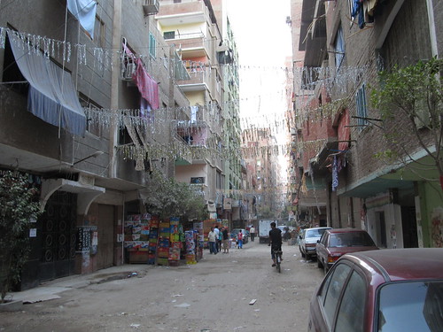
Posted: September 18th, 2012 | Author: mikel | Filed under: Cairo | 3 Comments »Ard El Lewa is an informal settlement in the west of the Cairo metropolis, built up over the past 30 years on agricultural land, its street layout still reflecting filled-in irrigation canals, towered over by concrete-framed multi-story buildings, just over the tracks from what was the old boundary of Cairo. Soon after the revolution, the local community built, to good standard, on and off ramps to the Ring Road (previously completely disconnected from their community), and successfully advocated for a public park on remaining precious open space that was planned for yet more housing. Yes, they built their own highway ramps! (not yet in OpenStreetMap)

Ard El Lewa Map, with images of urban challenges. Credit: unpublished report by Hanna Gad, Cluster
This is the atmosphere of enthusiasm and possibility that opened up at the very local scale in Egypt in the revolution. Across Cairo, “popular committees” organized to maintain security in their neighborhoods; some of these are evolving to “popular coalitions” focused on improving local neighborhoods through grassroots development. Modern Cairo has been a site of heavily centralized planning, large scale development, and lack of representation for local people in decision making. People did actually make many decisions about their living situation, simply by building informally outside a planning system beyond its capacity to handle the needs of a rapidly expanding Cairo, with estimates of 60-70% of Cairo’s population living in officially informal settlements. The pause of authority in the revolution resulted in countless grassroot initiatives, small and large, to remake the collective city and better serve residents. How this energy will be channeled, into politics, into restructered local government, or in something quite new, is a question being worked out right now in what seem to be typical Cairene chaotic ways.
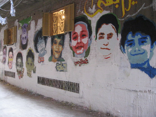
Murals painted by local children of Ard El Lewa, their faces and their dreams for the future
Into this potent brew, enter us, novices to Cairo (except the first OSM mapping party with Abdelrahman back in 2008). A year ago, Ford Foundation offered travel cover for us to come and share our experiences with urbanists, rights groups, and techonologists, and explore how community mapping and reporting technology could support Cairo’s changing urban life. Well, lots of our life intervened, and then we waited for the right moment, without presidential elections absorbing attention, and not during Ramadan or the heat of summer, and ended up with the right and latest possible moment for arrival here one week ago. That was just a day before this whole stupid mess with the video and embassy protests broke out, which would seem like exactly the wrong time to come. But as it turns out, Cairo is completely and utterly normal (for Cairo), and where we’ve worked at Cluster’s office, just a couple blocks away from Tahrir Square, you’d have no real idea anything was happening worthy (or really unworthy) of global media frothing.
Cardboard model of downtown Cairo in Cluster’s office
In the quick run up to our trip, we reached out and began email and phone conversations with collaborators Cluster, Takween, Megawra, Arab Digital Expression Foundation, Shadow Ministry of Housing, Cairo from Below, OSM Egypt, Meedan, Egyptian Bloggers, and more and others. Cluster have taken on the role of local host, for workshop space and community introductions; and ADEF are taking the lead on the technical side. Awesome to have the interest and welcome from these folks, especially during our rapid, steep and very much continuing education on urban Cairo. We formed a rough plan around collaborative discussion and design of our previous work, the context in Cairo, and a small pilot demonstration and collaboration with residents of Ard El Lewa in mapping and reporting, with whatever results as raw material for possible adaptation and expansion throughout Cairo. Now, things are constantly taking shape and reshape, and we’ll have plenty more to say soon.
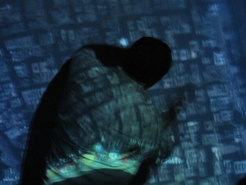
Slick Visualization of Mapping Tandale
Posted: August 14th, 2012 | Author: mikel | Filed under: tandale, tech | 1 Comment »When the community of Tandale mapped itself in OpenStreetMap, they opened their community’s data to the creativity of the entire web. This visualization from our friends at Development Seed shows the dramatic before and after mapping in Tandale, with bright cartography and integrated Ushahidi reports. Hope this sparks more ideas for Tandale and other communities around the globe just now adding their voice to the web. Maya posted the details on how they put the map together.

Check it out at explore.ramanitanzania.org.