
Mapping Participatory Budgeting in Kenya’s Counties
Posted: March 13th, 2020 | Author: Erica Hagen | Filed under: Accountability and Transparency, citizen feedback, Citizen Generated Data, Governance, kenya, openstreetmap, OSM, World Bank | Tags: Citizen Generated Data, Counties, Open Data, Participatory Budgeting | Leave a comment »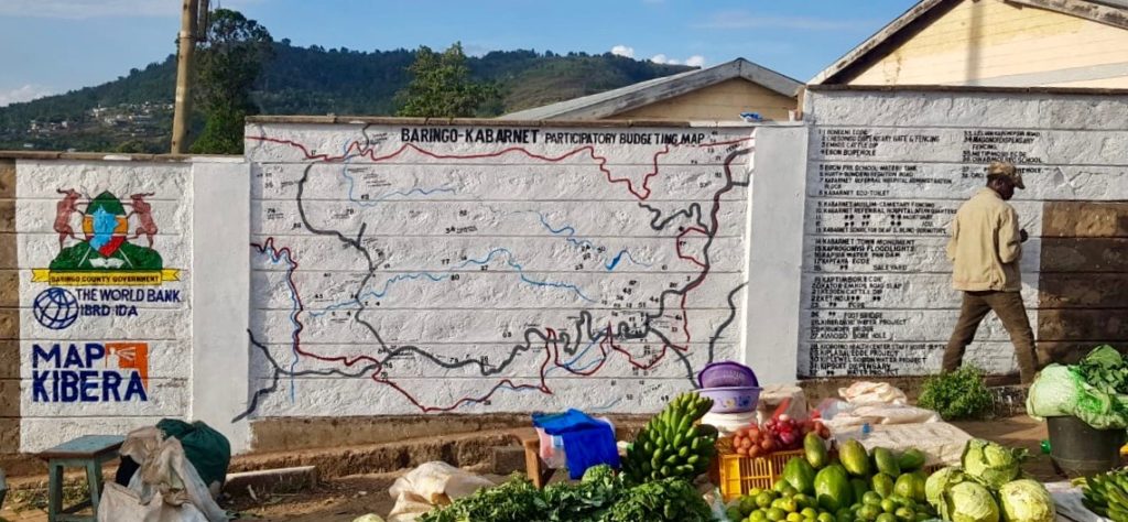
GroundTruth Initiative has been working for the past two years with three county governments in Kenya, along with partners the World Bank and Map Kibera Trust, to map and gather detailed feedback on county-funded projects. By training both county officials and local youth, while working cross-departmentally on data resources, GroundTruth has helped refine a process for citizen engagement which both increases transparency and accountability and provides much needed data and digital maps for the county.
In 2010, Kenya created a new constitution which focused on devolution of power to 47 new counties. Rather than focus development planning and budgets entirely at the national level, or in sub-regions which encompassed vastly different terrain and needs, the new constitution gave power to local officials and governors in the counties. Along with that came a need for new systems for finance and data. Starting up new processes and linking them to national systems was best done through digital means, but not all counties were ready technologically for these requirements.
In 2015, the World Bank began to support select counties to engage their citizens in a process of participatory budgeting. Citizens gathered in each subsection of the county, down to the village level, and prioritized the greatest needs. Budgeted projects included everything from new hospital wings to small dams and footbridges to new water points and classrooms. The process repeated each year, but it was difficult to track progress on the projects and to know where they were located so as to best allocate resources the following year. There were very few up to date digital or print maps showing county projects or pre-existing social resources and features.
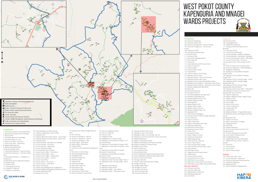
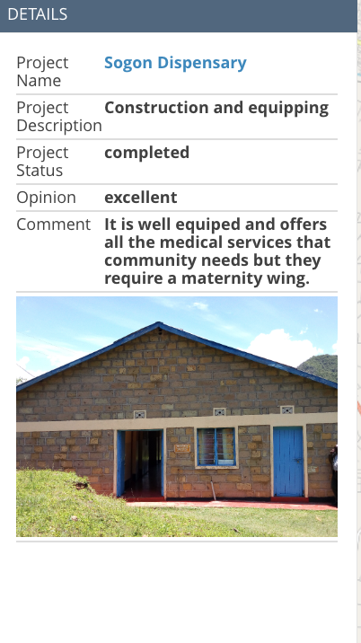
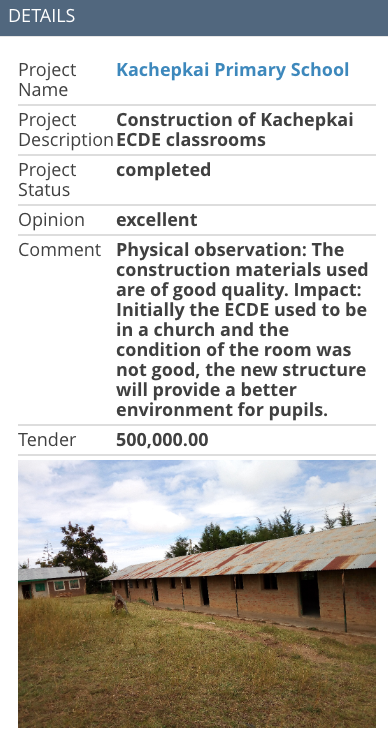
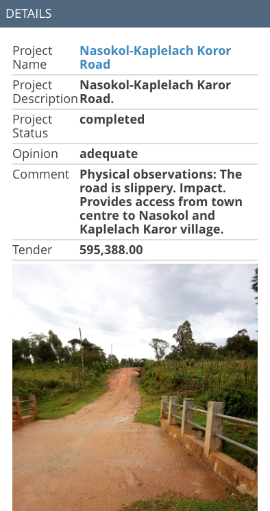
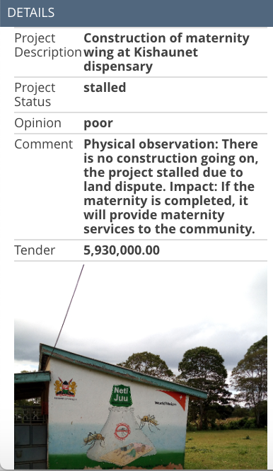
GroundTruth Initiative started working with counties in 2017 to help them create such maps. In partnership with Map Kibera Trust, GT worked with Makueni, Baringo, and West Pokot counties to use OpenStreetMap to develop a base map for their counties and map the county’s projects. As part of the process, county officials from Budgeting, M&E, Lands and Planning, ICT, and other departments were trained to use Open Data Kit and the Kobo Toolbox to survey their territory. In order to carry out the process efficiently and increase citizen involvement and project feedback, youth from each ward were also trained. Together, they not only mapped the project locations and basic details by visiting each project, but also photographed them and took notes on their completion status, operational status, and apparent quality.
This feedback was compiled by GroundTruth on a demonstration website for each county. The maps were also developed into print versions which could be used during the PB meetings themselves, and used and shared by officials who are often more comfortable with printed maps.
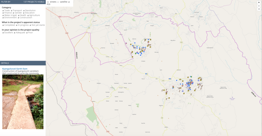
The work has paid off, as some counties have now completed a second phase of the project, receiving additional training on how to execute the process themselves and how to work with the data. All the maps and data stored in OpenStreetMap is open; the feedback on the projects is visible through the linked website. The purpose of the maps is to help the counties and the public to be able to track projects and budget expenditure. In the new phase of work completed in December 2019, budgeted contract amounts are also included on the site.
By working closely with both youth and government Data Fellows, Map Kibera and GroundTruth are currently supporting the counties to continue to utilize the process and better integrate it with their finance, M&E and planning departments, and work with their new GIS officers. Meanwhile, other counties are looking to work with the same process. The future of devolved governance and citizen accountability through mapping looks bright.
New Report Published on Sustainability in OpenStreetMap for Development
Posted: March 10th, 2020 | Author: Erica Hagen | Filed under: Governance, openstreetmap, OSM, Research, Sustainability, World Bank | Tags: openstreetmap, sustainability | Leave a comment »
A new report, written by GroundTruth director Erica Hagen for the World Bank’s GFDRR (Global Facility for Disaster Reduction and Recovery), examines sustainability challenges and strategies for the use of OpenStreetMap in developing countries.
Over the past several years, OpenStreetMap (OSM) has been used by an increasing number of aid and development organizations, like the World Bank’s Open Cities initiative, with the aim of supporting a wide variety of development and humanitarian objectives. OSM mapping has taken place in response to natural disasters (like the Haitian and Nepalese earthquakes), in order to empower slum communities (such as Kibera, in Nairobi), to help mitigate or prevent disease outbreaks (Ebola, and Malaria), or simply to promote the use of open map data among government officials and others already using GIS (for example in Kinshasa, DRC).
However, mapping efforts have frequently run into challenges as mappers and data users try to navigate issues of open data and technology to keep data and maps current and impactful. It can be difficult to keep trained volunteer mappers engaged, build and fund mapping organizations, engage governments productively, develop local management capacity, create successful mapping businesses around OSM, to name just a few.
This research explores the many facets of OSM in development and its “sustainabilityâ€. It examines the definition of sustainability, reviews existing literature about sustainability in ICT4D, and identifies four dimensions of “sustained benefit†which can help us to understand factors that will influence longer-term success. The paper identifies seven different kinds of actors which typically work with OSM in developing economies, and their particular challenges, illustrated by several case study examples.
The report then suggests a way forward for funders, practitioners, and others to move toward greater benefits for all given the constraints of OSM globally, the ethical considerations of digital open mapping, and the challenges of open source and open data projects generally as technology matures.
Sustainability in OpenStreetMap: Building a more stable ecosystem in OSM for Development and Humanitarianism
A white paper prepared for the Open Data for Resilience Initiative, GFDRR Labs, World Bank.