
The case for analyzing 2nd order impact of COVID-19 in settlements in Nairobi
Posted: January 24th, 2021 | Author: Erica Hagen | Filed under: Uncategorized | Tags: C2M2, Covid-19, education | Leave a comment »Nairobi has been the epicenter for Kenya’s Covid-19 outbreak during the global pandemic. In the early days of the pandemic, the Kenyan government imposed a fairly drastic lockdown, including closing in-country travel. This resulted in a massive economic impact. Some trade was allowed to continue, but most individuals were impacted. Schools were also ordered shut.
In September, only testing grades 4, 8, and 12 were reopened. Most schoolteachers in private, informal schools were without pay, or with severely lower pay since schools depend on fees.
Many individuals were forced to quarantine in hotels by the government, at their own expense, if they were found to be exposed or test positive. This also disrupted the economy, as many were providers. Other impacts included increased inter-familial problems, domestic violence and divorce.
Additionally, curfews were put in place and gatherings were limited in size. Many bars and restaurants were forced to close. Tourist dollars dried up. Tourism accounts for 8.8% of GDP, and 8.3% of jobs in Kenya. In slums, police enforced curfews and mask wearing, sometimes violently.
As of January 4, 2021, children returned to public schools. It remains difficult to assess whether the reopening alleviated some, if any, of the losses felt by the community.
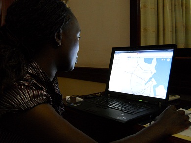
Cities Covid Mitigation Mapping Project (C2M2), from the MapGive program at the US Department of State, aims to use information obtained from schools serving those living Nairobi’s slums as proxy in order to understand the second order impact of COVID-10 on the education sector. GroundTruth, as the Nairobi partner, will use resources like OpenStreetMap, Kobo’s cloud database, and Map Kibera’s Open Schools Kenya website, to secure and visualize collected data. This data will also be used to understand how the residents have been responding to the closures as well as changes in sanitation, water access, and job losses. The team will also look at other impacted aspects of life in settlements, especially around water access and hygiene.
Equipped with research teams from Map Kibera, the project will learn how the lockdowns have affected the education sector and share recommendations on how to address these needs in the future. Findings and related data will be made available through OpenStreetMap and other open platforms for easy access by the public and government organizations so they make informed decisions on how to mitigate the second-order impacts of COVID-19.
Community Mapping: Frequently Asked Questions
Posted: July 16th, 2012 | Author: Erica Hagen | Filed under: Uncategorized | 5 Comments »Community Mapping is not a new term, but it seems to be enjoying a makeover due in part to the impact of new citizen-led mapping efforts, like Map Kibera, GroundTruth, and others using OpenStreetMap all over the world. It’s been popping up everywhere lately, so I thought it might be time to look into just what IS community mapping, exactly?
Policy Link reported back in 2002 that:
The terms community mapping and GIS are often used interchangeably. We define community mapping as the entire spectrum of maps created to support social and economic change at the community level, from low-tech, hand-drawn paper maps to high-tech, database driven, internet maps that are dynamic and interactive.
Meanwhile, an organization called Center for Community Mapping uses mostly Google maps to build software and then license it to others to use, with the expressed purpose of “empower(ing) grass-root stakeholders with mapping technology to foster participatory planning, community education, and cooperative organization”.
The first definition above is very broad, and doesn’t say anything about the role of community members themselves; the second does talk about empowerment but does not use open data standards.
Mikel recently presented and posted about this topic, saying “…the excitement of community mapping is beyond the data that’s being created, but the possibility of a fundamental shift in the power dynamics of how development is practiced. If people know the facts about their own lives, they have more power to call to account those institutions which are supposed to serve them, and ultimately, to improve their lives themselves.”
That’s the beginning of our approach. But, to be more explicit, here’s the GroundTruth take…
Frequently Asked Questions about Community Mapping:
Does Community Mapping need to involve the community, in the mapping?
Yes, it does. In the first definition above (the one that equates CM with GIS) it’s more about “mapping of a community” than “community mapping”. To me, that’s just plain mapping. Or perhaps, using GIS to understand a place, which happens to be a particular neighborhood.
Does that community actually have to live in the place where the mapping is happening? Isn’t it enough if they’re from somewhere nearby?
I’d again be pretty strict about that. If it’s called Community Mapping, people should be mapping in their own community, not the one next door. Why? Because we believe this is about participation, and not just about data collection. It’s also about giving people a chance to show what’s happening in their neighborhood from their point of view, in this case through the medium of a map, and about their own use of the information later.
How about if other people map the community and then later involve members of the community in a presentation about the mapping, is that still community mapping?
Not really. It’s just mapping, again, that happens to take place in a community.
Does the community need to own the information collected during the community mapping? Does it have to result in open data?
They don’t need to own it, but we do believe in free and open data as a critical part of community mapping. After all, the point is not to help companies build their commercial base, or to hand over more information to proprietary silos inside NGOs and governments, never to be seen again. The idea is to create a commons of information that can lead to greater transparency from the local level on up, and allow many people to leverage that information.
So, Community Mapping is another way of saying, “the community is actually doing the mapping”. Does that mean they’re using the technical tools themselves? Isn’t that too hard?
In our experience, most people learn quickly to use basic mapping tools, within reason. If students from a nearby university, none of whom live in the community, do the mapping, or if a great local NGO decides to map the local slums, hiring professionals or finding volunteers or using their own staff, none of whom reside in the slums, then that’s not community mapping. If people get their hands on the tools and learn to make the maps (as part of a larger process of participatory planning, information-based advocacy, or other local processes) that’s how we define the CM practice. Yes, we’re going pretty far here in saying that people actually do some technical work rather than perhaps walking around with a more “expert” mapper showing them what is where. There are probably ways that some technical support can be integrated, and certainly not everyone in the community needs to be doing the mapping. But it is part of the premise of OpenStreetMap, that such resources can be created by crowdsourcing, and they make it easy enough to do so.
It’s possible that community mapping can happen without a lot of technical training, though, and using different paper-based integrations (walking papers, etc). Perhaps the key point to make here is, if the goal of your project is explicitly to do community mapping, don’t assume that residents can’t or won’t want to do it themselves. And, as long as your project is done in such a way that prioritizing community empowerment and participation (and check on this carefully; it’s not common), coloring outside the lines of this FAQ is very much encouraged.
If I’m using OpenStreetMap, isn’t that automatically community mapping?
No. It’s great that you are using this user-generated free and open map of the world, though, and thereby contributing to the liberation of data worldwide for generations to come. Please don’t stop. And you might be doing community mapping, but not necessarily.
Is Community Mapping the same as Citizen Mapping?
The name is cleverly different from community mapping. While they could be the same thing, it’s interesting to consider that citizen mapping might imply less of a community-based process, and align more with movements like citizen journalism, imagined to be something done by individuals using their personal mobile devices and things like that. However, in places we’ve worked, that’s not quite how citizen media works either. At this point, I believe the terms can be used interchangeably, and we have definitely used both terms.
Does Community Mapping need to be Open?
I suppose not. But if it’s not, why not? Is it because some of the information collected will endanger a person’s rights in some way, infringing on privacy (household ownership data might)? If not, then yes, it should probably be open. Why? It’s a public good. This might require a fuller debate, but unless the community comes together and decides based on a clear understanding of the implications of free and open vs. private data that they need to restrict access, open should be default.
Does Community Mapping need to involve Citizen/Community Reporting or Media?
It is important to have a well-thought-out means for people that are making maps to use the information and build off of that base. A very effective way to do that is to introduce different kinds of reporting tools. This is because people get excited about their neighborhood and have more to say – the map can’t really finish the job, it’s just the beginning. Also, there’s a story (or several) behind each point of interest. I can imagine there are other ways that people can really engage around what they are seeing and use it, but the point is to go beyond the map somehow and allow people to tell stories with the data. Using something like Ushahidi or basic blogging and citizen journalism to illustrate community perspectives has been exciting in our work – in part because it is not restrictive about what people may want to say about themselves.
Is this the same as Participatory GIS?
Not quite. Participatory methodology should be part of both and PGIS is one of the inspirations for our work; community empowerment is also key to both. Traditionally, though, PGIS is closed and the information gathered in the process not intended to be shared openly (for re-use, etc). Also, that process doesn’t typically impart the technology skills to the participants.
So what exactly IS community mapping? Briefly.
Here’s my shot at the criteria.
1) Community creates/gathers the map data. That is, geographical coordinates alongside any other information (we’ve collected things like number of nurses in the health clinics, all the way to why one mother takes her child all the way to the other side of Kibera to see a doctor and what path she uses to avoid the street thugs).
2) Community also edits the map data themselves, and comes to agreement on the final product.
3) Mapped information is generally shared openly, online, contributing to commons, unless otherwise specified by the community and after a good discussion of the options.
4) Community uses the map afterwards, themselves. This might be the biggest challenge in practice, but there are plenty of people who have been using maps in local development for many years who can support on this point. We recommend introducing storytelling and media around the data through other tools for online expression. The mapping also can be part of a larger participatory development, local planning, or advocacy process.
Is community mapping the easiest/most efficient way to get the map I want?
Not always! In fact, it’s a time-consuming, complicated, logistically challenging, and just plain difficult way of getting a map made. But, getting a truly good map is usually time-consuming and difficult. Don’t forget, it’s the locals who know what and where everything is in the first place. Here you have to distinguish between the tendency to want a quick result, and the actual usefulness of what you want to produce in the long run. The idea with community mapping, when it uses OSM in particular, is that the resulting maps can be easily updated down the road when things inevitably change. You’re investing in creating local skills and a local network of mappers. Of course, you’re also investing in empowering citizens, but even if you just want your map this is a good way to make sure that the map isn’t useless in five years.
You can ask anyone who’s done one of the following things: community organizing, community development, participatory development, for a fuller explanation of the long-term benefits of the process and their challenges. We would place community mapping inside this constellation of methodologies.
But, what’s the point of making the map, if locals all know where everything is? Aren’t maps mostly for government planning or getting from place to place?
Well, not anymore. We think people can influence that planning (or cause it to happen at all) by doing community mapping. And, well, there’s a perhaps less celebrated motivation here for doing this mapping/reporting/making oneself “visible”. It’s been our exciting experience that people really care about having the truth about their lives come out and be heard, seen, verified, in essence validated. Of course, we’re working with communities that are in some way disenfranchised, but so are many others who would want to do community mapping. We started out (with Map Kibera) investigating the interest in, motivation and usefulness of these tools by people in the community, so I’m really looking at what I’ve seen matter to them.
I welcome your feedback and comments, below. Please discuss with us!
Instrumentalism vs Empowerment; or how to think like an artist
Posted: December 16th, 2011 | Author: Erica Hagen | Filed under: Uncategorized | Leave a comment »JR, the now-famous artist recently recognized with the 2011 TED prize, once plastered the rooftops of Kibera with close-up images of womens’ faces. The striking images often featured in our presentations about Map Kibera, because without knowing anything about the artist or the intent, shack rooftops covered in human visages resonated with what we hoped to do with our work: make the “invisible†visible, and humanize the apparently inhuman slum. A recent New Yorker article provides interesting insight into JR’s work.

JR is now undertaking a massive project of printing out other people’s self-portraits on jumbo poster paper so that their own images can be plastered like graffiti around their communities, or elsewhere.
He is, in a sense, taking the concept he started out with in Kibera and other marginalized neighborhoods and taking it to its logical conclusion: creating an army of graffiti-artist self-portraitists. Though he tried to practice his art in secret by hiding his identity and using renegade graffiti methods, it still earned him personal fame and fortune – turning the world’s attention back on him. It seems he’s again tried to push the lens back to the people he photographs, by serving as their printer. Whether it will succeed is not yet clear; to me the images start to look like a giant paper Facebook. But the example led me to consider further the meaning behind self-representation in a slum.
While building the various tools of representation in Map Kibera – creating a map, video, or blog post about oneself – the main thing everyone wanted to know was, but what changed in Kibera because of it? Even just a few months – or weeks – into the project. Representing oneself visually, online, on video, or on a map was considered a means to a specific end. Rightly so, I thought.
But, in fact, might it be considered disempowering to require that because self-representation is happening in a setting like an African slum, it must achieve measurable development “outcomes� Is pushing the development agenda along standard pathways minimizing other reasons for expression, ignoring the need for local ownership of information and news, or forcing a process of open-ended exploration by participants of what they hope to achieve to end too soon? There is a subtle difference between standard urban development or activism and the way that new media allows for what’s been called networked organizing. I’ve thought about these questions a lot while going between the world of development and the world of art, a rare border-crossing I’ve made at venues like Ars Electronica and Picnic.
Did people challenge JR the same way? It’s possible that they did, but because he’s positioned as an “artist†rather than a technologist or a development worker, the expectation isn’t there. The impact is in the change of perception, in the laying of claim to ones environment, in the increasingly common ability to declare, this place is “me”, or “us.” It’s not the same as ownership, but a form of it nonetheless. Again, it’s a way of asking, whose reality counts? Who does this place belong to? Perhaps along the lines of Occupy Wall Street, there’s a calling to witness, a reckoning, a question long before the hard work of hammering out answers can occur. The mental shift before the physical.
Maybe coming from the development paradigm, we didn’t consider this a viable option.
The core business of development has generally been to either impose, inspire, or create change (depending on your point of view) in circumstances, structures, and environments where conditions are intolerable on one level or another (that is, most of the planet).
The core business of art, well, that’s up for debate but its often seen as an end in itself- the change effected by art is subtle in the mind of the observer and artist, even when the art itself is strongly polemic. It’s not supposed that direct action need be taken but that a collective mental shift occurs.
In the article, JR mentions that people in places like urban slums are more and more sensitive to the way they are portrayed in the media. They are increasingly aware – and angry – about misperceptions. We have found that everywhere we’ve gone people are extremely motivated to control that image – and in so doing, control their environment. Once they’ve begun to take charge of their image, and become engaged citizens – yes, there’s a call for change, a call for results. And I still believe it’s useful to create information with a purpose – to map and write about specific topics while linked up with community groups that are active, in order to call for certain changes and guide planning. But I’ve also seen that there is a thrill of discovery – of engagement – that naturally comes with turning a camera or GPS on your own backyard, which needs to be valued. It’s a matter of saying, as with JR’s work: Here We Are. Repeatedly. And only once heard, to ask Now What?
Now, if you dig a bit deeper, you do find that even JR seems to have gotten caught up in this murky area. He’s started a foundation of some kind (the New Yorker doesn’t bother to explain, as though this is the simplest of things – to give some money to a slum) to help the places that he’s photographed in some way other than through his art. I can only imagine what happened in Kibera – where people are hyper-aware of the money to be made off their images, and those of their children. Any foreign photographer is not accused of getting rich off “art†(the concept being blatantly inconceivable there) but getting rich off selling someone’s image – possibly caught in a less than proud moment – to NGOs who then are seen to profit.
Nothing done in such a setting comes without moral strings attached, often pulling in different directions. This is the heart of the matter.
I’d like to suggest that we outsiders working in development (especially in new media) think a bit more like artists, giving those who make representations of themselves the freedom to decide what their stories “mean†– even more so when new open tools are being employed and certainly the world at large has not figured out everything they are capable of. Our job, perhaps, is to protect the internet from control and censorship, and promote access, continue to work to open and flatten this arena.
That’s not to let the artist off the hook. I wondered what was the real story behind JR’s posters. Did people balk at his camera? Did he have to explain, pay, or at least befriend them first? What’s the story of that encounter? And what do they think of him now? In Kibera, we found that he had to buy – and may continue to buy – his roof space from the residents who live beneath it. Art, like journalism, about a place that is not one’s home is always a matter of negotiation and examination of audience and purpose.
There is not one interaction in image-making – perhaps, in all of development – that isn’t morally fraught. But isn’t it more interesting to let that be the starting point for real discussion of the meaning and goal of self-representation?
Tanzania: Involving Community Organizations
Posted: August 30th, 2011 | Author: Erica Hagen | Filed under: Uncategorized | Leave a comment »
The first community forum went well. It was deal breaker for the project in the sense that if we didn’t get the community to share our ideals and objectives, making them their own, then the project would fail. Now the map is basically complete for first draft. We have enough of a basemap so we can now support platforms like Ushahidi and enable blogs to be geolocated.
Collecting the data and producing the map, as I’ve previously mentioned is only a first step. The same can be said for involving the students and community members. By creating a small nucleus of highly engaged people, proficient in mapping and storytelling techniques understand the project, they can evangelise the project to others in their community. This ‘infects’ the community from the inside allowing for more people to interact and share the project without ‘outside’ involvement. This will in time hopefully reach a plateau where the entire process of updating the map, reporting and blogging becomes self-sustaining using only the initial equipment and investment.
With this in mind, in the build up to the final community forum of the project (where presentations will be made to the community as a whole ie. interested citizens, civil servants and politicians) we gave a ‘pre-release’ talk to ten community based organisations. The format for this was quite simple, the students introduced the map with it’s features and intended functionality and the community members introduced the storytelling elements.
Within this process I spent most of it being a photographer and an observer. It wasn’t quite seeing the monster you created evolve but when presenting both students and the community are owning the process. The community organisations engaged in a Q&A session then participated in reporting using Ushahidi.
During the Q&A many questions dropped out regarding the future of the project and how the map can be used further. Because we are still formulating the future strategy it is difficult to say what the next step will be, but it will be along the lines of franchising to other areas overseen by community, NGO/CBO and Ground Truth, constructing this framework will be taking place for much of the coming week.
We are also printing the map and distributing it. This is key; in using Open Street Map, the collected data is freely available for viewing and data analysis without restrictions like a prohibitive licence. However accessibility to computers and internet understandably is a problem in communities like Tandale. To enable the community to view their map we will be printing A2 maps for placement in the sub-ward offices and printing A4 sub-ward handouts.
By placing it in a communal areas for each of the communities, we aim to reduce the barrier of people using the map by making it accessible. This process has started with our small nucleus of students and community, expanded by involving community based organisations and will be expanded further by integrating the map into governmental offices at the sub-ward level. Having the map built into the fabric of the community from the beginning of the project should make further incremental additions easier.
Community organisations being fully involved in the project is the next step, the process has been started and the ball is rolling. However Eid is coming in the next week, so everything is going pole pole, Swahili for slowly slowly. However tangible results are starting to become very clear, on all levels with all stakeholders.
Originally posted by Mark Illiffe on his blog on August 29, 2011. Mark is working with GroundTruth in Tandale, Dar es Salaam this month introducing community mapping and reporting to Dar es Salaam residents, in a project supported by the World Bank and Twaweza.
Dar es Salaam – Introduction to Informal Tanzania
Posted: August 15th, 2011 | Author: Erica Hagen | Filed under: tandale, Tanzania, Uncategorized | 1 Comment »In June, GroundTruth began planning a project in Dar es Salaam, supported by the World Bank and Twaweza. We’re training in both mapping and citizen reporting in Tandale, an informal settlement of Dar. During August, we’ll be working with both community members and urban planning students at Ardhi University to create maps and build reporting resources for this community.
Since Tanzania is so close to Kenya, we wanted to involve Map Kibera Trust members as much as possible in training their neighbors. Though they share a language, socially and politically Tanzania is about as far from Kenya as you can imagine for a country whose border with its neighbor was only drawn during the last century. The socialist roots in the country, as well as the nation-building efforts of Julius Nyerere have left their mark. Kibera is also a far cry from Tandale, as we found out in June – with a much lower population density, it suffers from problems of rapid urban growth and lack of planning, but appears much more like a rural village, with space at less of a premium and social problems that appeared to us to be much less acute. Computer and internet usage also aren’t nearly at the level they are in Nairobi. It will be interesting to see how the techniques we’ve used in Map Kibera translate here.
Map Kibera Trust members Simon Kokoyo, Lucy Fondo and Hassan Abdalla, along with project leader Mark Iliffe, have been launching the activities this past week. We’ll repost some of their blogging to paint a picture of the activities.

Simon posted on Mathare Valley Blog about the first day’s forum in Tandale:
“The forum was started off by a speech by Tandale Word Executive Manager. More than 37 people including community members. Participants were happy to learn that they can be able to produce a map about their community and use to engage with the government and NGOs in the development and improvement of infrastructure. Currently Tandale and most of Dar es Salaam appears as blank spot on the Open Street Map platform.
Some of the suggestion participants shared on how maps and the use of citizen reporting can be used for development included;
- The map produced will help improve dialogue between community and development partners for infrastructure improvements
- Through citizen mapping, the community will highlight its own issues as opposed to mainstream media which focuses on mostly the negatives
- The use of map and community reporting will help stimulate adoption of local solution to problems faced by the communities
- The community will acquire new skills in ICT helpful in mass circulation / distribution of information
For the next four weeks, Map Kibera Trust will be in Dar es Salaam training community members and students on community participatory mapping skills, use of simple technologies and citizen reporting.
LESSON LEARNT: Communities are capable of interpreting maps they have participated in developing and using it to initiate dialogue with development partners and government agencies. What communities needs is ‘method’ of presenting the data collected.”
Lucy and Hassan will be writing updates on most days about their experience. Their posts are on Map Kibera’s blog.
Here is Lucy’s take on working with women in Tandale: “Today (9/8/2011) I was in the company of community members from Tandale, Dar es Salaam to help them undertake mapping of their own community and also talk about community media. To be in Tandale, Tanzania was exciting but being with follow women was even more exciting. When starting the discussion about the importance of mapping, it occurred to me the issues which women were relating directly consumed a lot of time.
When I asked one of the women what she would liked to be mapped in her area, she said, toilets and water points. Reasons, she said in Swahili “wakati wa mvua, jamii yangu (Mukunduge,one of the 6 sub-wards) ni kawaida mafuriko na maji machafu kuwa kila mahali†(when it rains, my community (Mukunduge) is usually flooded with dirty water everywhere).  She believes by having a map, she can be able to talk confidently and convincingly with the municipal council about flooding problem in her community.
I have been in Dar es Salaam in Tandale and Sinza areas. One can witness the dominance of men in many cyber cafes. There is higher usage or percent in these cyber cafés.
Also some women were happy to learn that they will be trained on how to use video cameras  to tell their own community stories which will be put in the internet and read worldwide . I am happy that we have been able to identify both women and men who will be trained on the use of global positioning system (GPS) and how to download data into the computer.”
And, Lucy comparing Tandale’s waste collection with Kibera’s:

“Most of the farmers around  Dar-salaam take their agricultural produce to Sokoni market(Tandaleward).The most amazing thing about this market is that you will always see a municipal council’s lorry packed somewhere around ready to collect garbage from the market.For me, this is welfare because when I compare Sokoni market with Toi market i.e. in Kibera, I see I a big contrast. In Toi market you will never see a lorry coming to collect gabbage.The burden of garbage collection is usually left to the business owners….
My opinion is for the City Council of Nairobi to atleast deploy two lorries on weekly basis for garbage collection. I believe with this done, it will help in maintaining a clean and safe environment free from pests and diseases.”