
Ard El Lewa field workshop
Posted: September 24th, 2012 | Author: mikel | Filed under: Cairo | 1 Comment »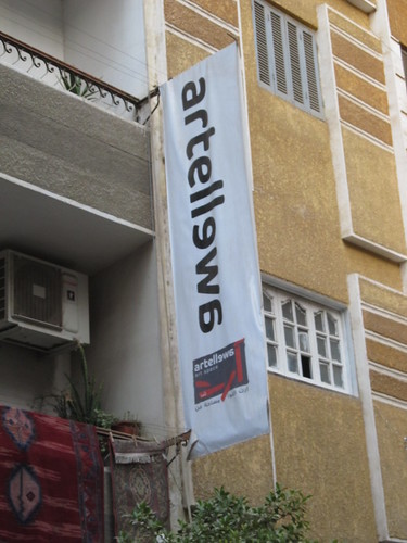
As mentioned in a previous post, we’ve been here in Cairo for the past couple of weeks working with local architects, techies, grassroots activists, and interested residents of the Ard el Lewa community on a quick demo and experiment intended to catalyze the use of open technologies at neighborhood level.
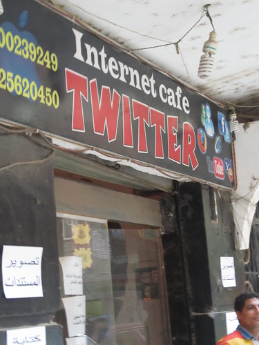
Four four evenings, after the work day was done, we gathered in the screening room of Art El Lewa, an artist space, or next door in the “Twitter” cyber, made this small but good start on mapping Ard El Lewa, and posted a few reports to this demo neighborhood CrowdMap. At the end, on my birthday, I received a great present with the announcement of formation of an Ard El Lewa OSM group!
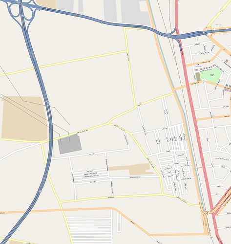
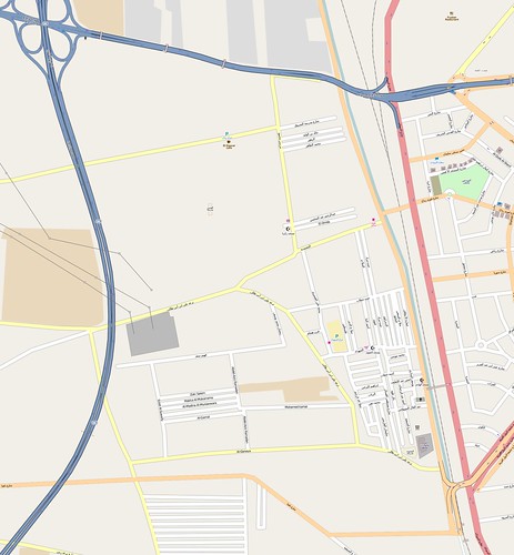
Here’s the before and after. Look closely. From absolutely no POI features at all, there’s over a dozen mosques, churches, schools, bakeries, parking; and several corrections to street names and additional streets. This was edited in just a couple of hours.
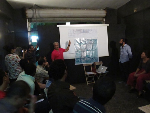
There was a terrific amount to cover in a few quick evenings, not only the techniques of OpenStreetMap and Ushahidi, but more fundamentally, the concepts of thinking and working geographically toward a particular outcome. Zaazaa from Megawra and Omar from Cluster led the initial meeting, in a packed room of participants, including about 12 from Ard El Lewa: from the youth center, popular coalition, political parties, women’s groups; and another 12 from groups outside with interest in the process. Ard El Lewa has strong grassroots networks, and Cluster has been collaborating with them, so it was easy for them to mobilize. Everyone drew conceptual maps on paper of their journey from the bridge (over the railway, one of the few entrances to Ard El Lewa), to Art El Lewa, and we explored the different ways of representing and thinking about space. Then a “find my house” session with Google Earth, that could’ve gone on for hours.
Most interesting were presentations from a few local amateur mapmakers, including a grassroots leader and tailor whose hand-drawn detailed designs for a new transit station at the entrance to Ard El Lewa clearly reflect the attention to detail in his day job craft. And another presentation by a young researcher, who’s been collecting street names and their history in Ard El Lewa, using spreadsheets and hand drawn maps; the names are usually sourced from the first person to build on the street, the name of the canal that formerly laid there, a nearby shrine, or some other prominent landmark. And if that wasn’t enough, Abdelrahman comprehensively covered the basic concepts of OpenStreetMap and GIS, including the differences between raster and vector data.
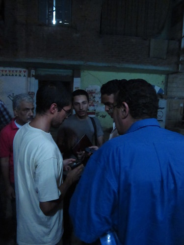
The second day got everyone into the streets, with GPS, and they totally got it, and collected an epic number of points. Ahmad from ADEF learned the GPS in the car ride over, and delivered the training on arrival. Afterwards a detailed demonstration and training on JOSM was conducted in the cyber.
On the third day, we presented some examples of how we’ve used maps and media elsewhere, and then Omar led a discussion session to brainstorm uses of the maps and reporting tools locally. This was one of the most inspiring moments, ideas growing from expected things, like using the maps in the planning of new infrastructure in Ard El Lewa, to things like custom book covers for local school children illustrating the location of their school on the map, mapping graffiti art works, developing a website for the community including job postings, and a local business oriented map, whose collection and distribution could create entrepreneurial opportunities for local youth (this idea from the local youth themselves). There were many more that flew by me in Arabic, but honestly, I’ve never seen a community so ready to put technology to work for their own agenda.
It’s true, the number of attendees reduced over the week, which is pretty typical. But the remaining core represented most of the folks from Ard El Lewa, now a seemingly dedicated lot. The rest of the two days focused on using registering with OSM, using JOSM, and using Ushahidi. We discussed how to tag the narrow, unpaved roads of Ard El Lewa, something which seems to require new classifications. The Ard el Lewa Ushahidi crowdmap instance took some of the concepts from the previous days, and put them together onto a website. Those who had stuck with the training until the fourth day all logged in and became administrators of the site, and developed categories like Trash collection, and Education. By the next day at least one new post had been made on the instance, showing that in just an hour or two members had been able to pick up the basics of creating and also approving posts. Interestingly the new post, complete with photos, was about children at a local school staging a protest against the now infamous Youtube clip “Innocence of Muslims.”

And as usual, it was a challenging endeavor. There was a lot of material to cover, and not just techniques. Abdelrahman powered through so much knowledge, every day. This would usually be stretched out over a few days, rather than a few evenings. There was so much to explain, participants had less time than I would have liked actually doing. We were also challenged by being split between two open door venues, a separate space for lecture and working, which is sometimes good, but is hard when trying to explain technicalities. Ahmad Gharbeia did hook up a local, open source, screen-casting system using shared desktops, which worked pretty well for sharing JOSM training, and delighted the manager of Twitter. But that was on top of the technical challenge of a cyber cafe that reverted every machine back to a stored disk image every reboot, making it impossible to install the tools permanently. They were very nice however, and served me tea every evening, and the machines were in pretty good condition, with decent connections, and even free wifi for laptops. We, the collective trainers, never had a good opportunity to really collectively pre-plan the program. We all threw in a lot of ideas, and with timing and the moments, did a lot on the fly, but roles were not always coherent. I guess that’s fine, and I practiced stepping back and letting things unfold as they may!
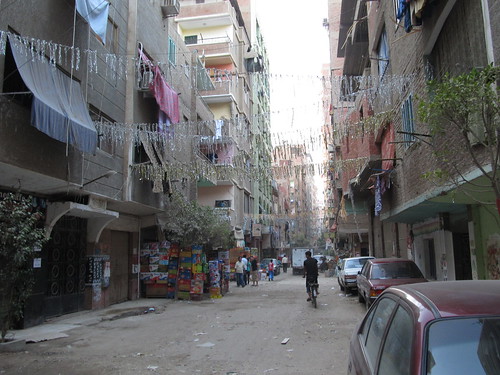
Ard El Lewa has a vibrant street life. Hanna said “it’s one of the beautiful things about the informal”. Everything is out in the open, on the street, shared (and of course for sale). I’m grateful that Ard El Lewa was so welcoming to us, GroundTruth and all of the collaobrators. There’s a real tangible pride in what they’ve built for themselves. And with their declaration to form a mapping community, I’m very motivated to help figure out the shape of continuing support, so Ard El Lewa can put themselves on the map.
Cairo Urban Grassroots
Posted: September 18th, 2012 | Author: mikel | Filed under: Cairo | 3 Comments »Ard El Lewa is an informal settlement in the west of the Cairo metropolis, built up over the past 30 years on agricultural land, its street layout still reflecting filled-in irrigation canals, towered over by concrete-framed multi-story buildings, just over the tracks from what was the old boundary of Cairo. Soon after the revolution, the local community built, to good standard, on and off ramps to the Ring Road (previously completely disconnected from their community), and successfully advocated for a public park on remaining precious open space that was planned for yet more housing. Yes, they built their own highway ramps! (not yet in OpenStreetMap)

Ard El Lewa Map, with images of urban challenges. Credit: unpublished report by Hanna Gad, Cluster
This is the atmosphere of enthusiasm and possibility that opened up at the very local scale in Egypt in the revolution. Across Cairo, “popular committees” organized to maintain security in their neighborhoods; some of these are evolving to “popular coalitions” focused on improving local neighborhoods through grassroots development. Modern Cairo has been a site of heavily centralized planning, large scale development, and lack of representation for local people in decision making. People did actually make many decisions about their living situation, simply by building informally outside a planning system beyond its capacity to handle the needs of a rapidly expanding Cairo, with estimates of 60-70% of Cairo’s population living in officially informal settlements. The pause of authority in the revolution resulted in countless grassroot initiatives, small and large, to remake the collective city and better serve residents. How this energy will be channeled, into politics, into restructered local government, or in something quite new, is a question being worked out right now in what seem to be typical Cairene chaotic ways.
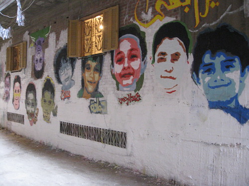
Murals painted by local children of Ard El Lewa, their faces and their dreams for the future
Into this potent brew, enter us, novices to Cairo (except the first OSM mapping party with Abdelrahman back in 2008). A year ago, Ford Foundation offered travel cover for us to come and share our experiences with urbanists, rights groups, and techonologists, and explore how community mapping and reporting technology could support Cairo’s changing urban life. Well, lots of our life intervened, and then we waited for the right moment, without presidential elections absorbing attention, and not during Ramadan or the heat of summer, and ended up with the right and latest possible moment for arrival here one week ago. That was just a day before this whole stupid mess with the video and embassy protests broke out, which would seem like exactly the wrong time to come. But as it turns out, Cairo is completely and utterly normal (for Cairo), and where we’ve worked at Cluster’s office, just a couple blocks away from Tahrir Square, you’d have no real idea anything was happening worthy (or really unworthy) of global media frothing.
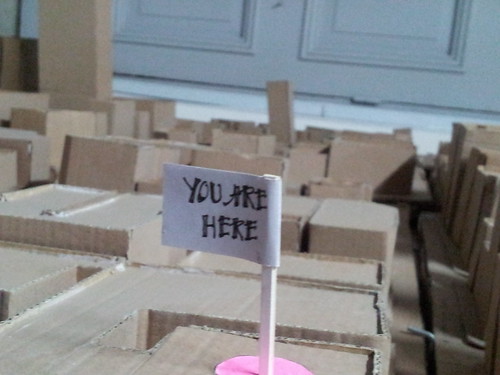
Cardboard model of downtown Cairo in Cluster’s office
In the quick run up to our trip, we reached out and began email and phone conversations with collaborators Cluster, Takween, Megawra, Arab Digital Expression Foundation, Shadow Ministry of Housing, Cairo from Below, OSM Egypt, Meedan, Egyptian Bloggers, and more and others. Cluster have taken on the role of local host, for workshop space and community introductions; and ADEF are taking the lead on the technical side. Awesome to have the interest and welcome from these folks, especially during our rapid, steep and very much continuing education on urban Cairo. We formed a rough plan around collaborative discussion and design of our previous work, the context in Cairo, and a small pilot demonstration and collaboration with residents of Ard El Lewa in mapping and reporting, with whatever results as raw material for possible adaptation and expansion throughout Cairo. Now, things are constantly taking shape and reshape, and we’ll have plenty more to say soon.
Slick Visualization of Mapping Tandale
Posted: August 14th, 2012 | Author: mikel | Filed under: tandale, tech | 1 Comment »When the community of Tandale mapped itself in OpenStreetMap, they opened their community’s data to the creativity of the entire web. This visualization from our friends at Development Seed shows the dramatic before and after mapping in Tandale, with bright cartography and integrated Ushahidi reports. Hope this sparks more ideas for Tandale and other communities around the globe just now adding their voice to the web. Maya posted the details on how they put the map together.

Check it out at explore.ramanitanzania.org.
Msilikale and Equipment in Dar
Posted: July 27th, 2012 | Author: mikel | Filed under: tandale, Tanzania | Tags: Tandale | Leave a comment »When we returned to Dar es Salaam last month, we planned to assist a variety of partners to build a much larger and more sustainable program in the city based on the Tandale pilot. This continues, but may take some time to develop. So, at minimum we committed ourselves to put in place the means for the Tandale community to be able to continue to map and report. The key missing pieces were equipment, and someone to help out. The fine folks at MapBox lent a hand on the equipment side, with a small donation towards two sets of laptop-GPS-camera-modems for use in community work in Dar es Salaam. ASANTE!
Some snaps from Tandale of mappers getting to grips with their new equipment.


We were also able to bring on Msilikale Msilanga part time to help out with keeping things going in Tandale. We also loaned out some GPS devices to CCI for them to use as they continue to work on mapping with one of our previous trainees, Reginald, in Keko Machugwa.
Here’s Msilikale in his own words….
Who am I?
I participated in the Tandale Project from Ardhi University, as a student during that time. I now have a Bachelor of Science in Urban and Regional Planning, with knowledge and experience of mapping using different software such as QGIS, MapInfo, etc, as well as knowledge of OpenStreetMap. I am now helping the Tandale community with reporting and mapping Tandale.

What I am doing in Tandale
The following are the activities that I am doing to help the community who are interested to do more mapping using OpenStreetMap and reporting using the blog and Ushahidi.
1. Â Train the Tandale community every Sunday
This is one of the things I have decided to do because most of the community who participated in the project had the knowledge from the training in the project, but it has been a long time now and they don’t remember how to use the equipments. So I am training them every Sunday when they are free.
2. Â Helping the interested community when they fails
The Tandale community see me as part of their family, so whenever they fail in anything especially mapping and reporting, they can contact me at any time and I help them through the mobile phone especially when they want to use the equipments and they don’t know how to go about it.
3. Â To connect the Tandale community with Ground Truth (GT) and Centre for Community Initiatives (CCI)
Because I can also communicate with Ground Truth and CCI now, I am acting like a bridge to bring the community feedback, and if there is a problem I am the one to report to either CCI or Ground Truth.
4. Â To take care of the equipments
If one of the equipments has a problem the community reports to me. If the problems are from technical (the computer is not working for example) I can solve that problem, but if I fail to solve the problem I contact Ground Truth or CCI for help.
5. Â Encourage the community in what they are doing
This is to help them to do more mapping and reporting and reminding them the importance of doing it.
6.  Find the way to make these reports to be heard by responsible people
This can be the government, or  NGO or CBO, that can help in any way with the problems raised by the Tandale community; even facilitating meetings with the bloggers so that to make Tandale voice to reach far and get help.
Dar es Salaam: Tandale and beyond
Posted: July 24th, 2012 | Author: Erica Hagen | Filed under: tandale, Tanzania | 1 Comment »GroundTruth recently returned from a trip that included a lovely stop in Dar es Salaam, Tanzania.

Football at sunset in Tandale
Last year, the World Bank and Twaweza sponsored a brief mapping pilot there which was completed by GroundTruth in partnership with Map Kibera Trust. On the community side, the pilot involved a partnership with a local associate of Slumdwellers International known as the Center for Community Initiatives. The Tandale mapping exercise, while successful in many ways, unfortunately did not continue beyond the pilot month as hoped. This was partly due to the unfortunate destruction of all of the mapping and computer equipment in the massive floods of December 2011.
We were therefore excited to be able to return this June, again in partnership with the World Bank, and take a look at the successes and failures of the pilot and possibilities for growth in Dar.
While the mapping process initiated last year was very much based on the Map Kibera work in Kenya – for example, training community members to do their own mapping and involving the community in forums to share ideas and results, there was also a new element: involving University students. We made a point of engaging the Ardhi University students of Urban Planning in such a way that they were learning alongside an equal number of residents of Tandale, exchanging knowledge and learning about the issues in Tandale. It was a great practical experience for students. Meanwhile, Tandale residents appeared to appreciate the attention from students and their help in getting the important local issues mapped and recognized.
During our recent trip, it was clear that for some students, the relationship with the Tandale community leaders (and the multiple challenges they face in areas like sanitation, wastewater management, infrastructure, and more) had made a strong impression. A few students had continued to talk to some of the residents and try to find ways to support their continued work, without institutional support but purely under their own initiative. This was encouraging, and a great signal of success or potential success. One student, Msilikale Msilanga, had even returned to Tandale several times and made reports via both email and on the Tandale Blog about various emerging concerns.
Part of our enthusiasm to return to Dar was therefore to help Msilikale and other motivated students to continue to support the most motivated community members and build off the ground work laid last year. GroundTruth brought some new equipment (partly donated generously by Development Seed) to support this goal.

Msilikale with Tandale participants
One of the first things I did was to visit Tandale and ask the participants there about their experience last year. Not surprisingly, the main thing they wanted to talk about was the failure to establish a means of accessing any equipment after the pilot. In a place like Tandale, cybercafes are rare or distant. Certainly, accessing something like a GPS or a software like JOSM would not have been possible independently.
I explained (along with Mark Illife, the primary GT trainer last year) that unfortunately Mark had taken very ill and had to leave quickly at the end of the pilot; meanwhile, no suitable location to store equipment had been agreed upon. It might seem like a simple thing: find someone/someplace who can properly care for, house, and monitor access to a few pieces of equipment: laptop, modem, GPS, camera. The truth is, however, it’s not simple at all. In fact, we have spent a great deal of time and effort during and since our trip to resolve this same issue with the new equipment that we brought. We will wait and see if the plan succeeds. The problem is that in Tandale (like other informal settlements in Dar) there are few offices or community-based organizations which might suitably house equipment. The Ward Office was a great host, but it closes around 5 pm and on weekends, when most participants are free. Situating equipment means establishing a close partnership and contractual agreements, which also takes time (and is what we’ve done this time through).
It’s very important to realize that in a community like Tandale, or perhaps any time you are working alongside community members – that is, in a geographically defined area where people are associated together in various ways, and know each other, and face the same problems day to day – it’s not sufficient to simply bring in a “pilot” and then showcase the results without continuity. This is a main premise of Map Kibera as well. One is entering into the lives of people and introducing something in hopes of having lasting impact. I was glad to see that residents were still enthusiastic that the pilot could still lead to something nearly one year later, and that GT was able to find a way to continue.
I then supported Msilikale and two other former Ardhi students in running two new training sessions on reporting using the Tandale blog and Ushahidi instance, Ramani Tandale. These sessions were very exciting. Participants had a LOT to say about their community. We not only introduced technology, but spent a good deal of time coming up with story ideas, thinking about what and how to tell the stories, and writing them out in small groups.

Combining some of the community “elders” – members of the Slumdweller Federation group or other local leaders – with more computer-savvy local youth was very fruitful. The elders had many story ideas, as though they had just been waiting for someone to ask. They finally had a public way to air their grievances and talk about their hard work through the Federation chapter. Meanwhile, the youth could quickly type and pick up the posting skills.
Tandale, it should be mentioned, is really not much like Kibera. The population is smaller and the area is less dense; community leaders work closely together with the Ward Officer and other local political figures; the social problems one finds are less contentious, less likely to involve violence or conflict. The feel is more rural or village. This is my impression, and it tends to extend over the whole of Dar. Dar is no Nairobi, and any program should be adapted to this variation in how things get done. Above all: people rely on, and trust government far more, relatively speaking.

Reginald, an Ardhi student, talks to a resident about a persistent flooding problem

Visiting Keko Machungwa Ward Office
Another exciting development since our work last year was that CCI had already hired one of the Ardhi students to help them produce a similar map in another settlement where they were working, Keko Machungwa. CCI, like others affiliated with Slumdwellers Federation, assists slum residents to collect and use local information to determine their own development needs and find ways to serve them, or to band together and advocate for change. CCI was also excited about the possibilities of local reporting and media to highlight these issues, so we’ve partnered with them in our recent bid for the Africa News Innovation Challenge. We were glad to see that mapping was actively underway, and local leaders were watching us work on online reporting tools in Tandale. Blogging was in high demand.

Map Editing in Keko Machungwa
Following up on Tandale was only one reason for the visit. We had also contracted with the World Bank to help advise on the future of mapping and reporting in Dar, especially with regard to the strategy for engaging Universities. We spent a good deal of time meeting with interesting organizations like KINU, a new tech “hub” space and tech entrepreneurship support; TanzICT, a Finnish government support to the Tanzanian government’s COSTECH ministry; Twaweza, and others.
It was exciting to see that Dar is beginning to get a bit of the Nairobi tech fever, but given its unique culture and social context, the innovations that come out of Tanzania are bound to be different. Those which are adopted will also be uniquely Tanzanian. Anyone who has visited these neighboring countries cannot help but notice the stark difference in cultural “personality”, like two twins who grow up as opposites. Risking a bit of essentialism…I can’t help but think Nairobi is like the athletic, popular and brassy twin, outgoing and ambitious but liable to get into big trouble from time to time, always on the hustle. Dar is the quiet one, thoughtful and introverted, always generous, laid-back and daydreamy.

Msilikale presenting Tandale at ANIC event
We witnessed a bit of the differences at an event set up by TanzICT, KINU and COSTECH to publicize the Africa News Innovation Challenge. The event brought together journalists and young software developers to brainstorm some ideas to apply to the challenge. We’ve watched Nairobi’s iHub, now featuring several such events a week, grow up from just an empty space in 2010. Now this new space in Dar has just gotten off its feet. It’s therefore exciting to see what can come of it. I don’t think of this as being “behind” or “lagging” at all, I believe that Dar’s tech scene will certainly have its day and possibly will quietly issue in some of the more effective ICT and media projects and ideas. There are benefits to being just out of the spotlight yet close enough to watch and absorb. Msilikale was able to entertain the crowd with his presentation in Swahili about Tandale, including the new blog posts and Ushahidi posts on Ramani Tandale.
We’re certainly going to keep watching. GroundTruth recently posted an application to ANIC which would bring together Map Kibera and CCI in an exciting new community-based reporting platform designed to meet the needs of both Dar and Nairobi informal settlements. A revolution in networking and raising the voices of slumdwellers is brewing, and we hope to be able to support it in any way we can.